Airborne Gamma Survey Program
National Operational Hydrologic Remote Sensing Center
National Weather Service , NOAA
Overview
Operational Snow Survey Program
Operational Flight Line Network: Survey Locations
Airborne SWE Measurement Theory
Sensor/Instrument Description
Airborne Snow Water Equivalent Measurement Practice
Ground-based Snow Water Equivalent Measurements
Airborne Snow Survey Program Products
Explanation of Airborne Gamma Data Format (SHEF)
Winter Airborne Snow Survey Schedule
Summary
The National Operational Hydrologic Remote Sensing Center (NOHRSC) has
developed, and currently maintains, an operational Airborne Gamma Radiation
Snow Survey Program to make airborne Snow Water Equivalent (SWE) and soil
moisture measurements. Airborne SWE measurements are used by NWS Weather
Forecast Offices (WFO) and NWS River Forecast Centers (RFC) when issuing
river and flood forecasts, water supply forecasts, and spring flood outlooks.
 Both SWE and
soil moisture tend to be spatially variable across the landscape, making
it difficult to collect an adequate number of representative ground-based
point measurements. Using airborne gamma radiation detection methods, information
on SWE and soil moisture is collected over entire flight lines, providing
a more representative sample of the mean areal conditions on the ground.
Airborne gamma radiation measurement remains one of the most successful
methods of acquiring spatial information on SWE and soil moisture.
Both SWE and
soil moisture tend to be spatially variable across the landscape, making
it difficult to collect an adequate number of representative ground-based
point measurements. Using airborne gamma radiation detection methods, information
on SWE and soil moisture is collected over entire flight lines, providing
a more representative sample of the mean areal conditions on the ground.
Airborne gamma radiation measurement remains one of the most successful
methods of acquiring spatial information on SWE and soil moisture.  NOHRSC
uses this information to generate maps of the spatial distribution of SWE
for use by NWS River Forecast Centers to assist in streamflow and flood
forecasting. Two NOAA aircraft are operated full-time by NOHRSC thoughout
each winter and spring to collect this information from across the United
States. Data from each survey are transmitted directly to NOHRSC, where
the data are archived, processed, and made available to NWS forecast offices,
other government agencies, and to the general public.
NOHRSC
uses this information to generate maps of the spatial distribution of SWE
for use by NWS River Forecast Centers to assist in streamflow and flood
forecasting. Two NOAA aircraft are operated full-time by NOHRSC thoughout
each winter and spring to collect this information from across the United
States. Data from each survey are transmitted directly to NOHRSC, where
the data are archived, processed, and made available to NWS forecast offices,
other government agencies, and to the general public.
This document describes key aspects of the Airborne Snow Survey Program
and the technique used to make airborne snow and soil moisture measurements
using natural terrestrial gamma radiation. It provides a brief description
of the following:
- How airborne gamma radiation SWE measurements are made;
- What the airborne measurements represent and how (and why) they differ
from ground-based SWE measurements;
- How the measurements can be modified by Service Hydrologists and other
end-users using alternative soil moisture assumptions;
- How and when airborne data are transmitted to NWS field offices; and
- Details of snow survey mission scheduling and RFC communication necessary
to ensure an effective airborne data collection season.
Operational Snow Survey Program
NOHRSC maintains the Operational Airborne Gamma Radiation Snow Survey
Program from its office near Minneapolis, MN. The program makes airborne
SWE and soil moisture estimates over a network of 1900 flight lines covering
portions of 25 states and seven Canadian provinces.
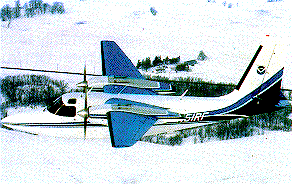
The NWS owns a twin-engine Aero Commander dedicated to provide program
support 12 months of the year. Two additional NOAA aircraft have been calibrated
for airborne radiation data collection and are available for program support:
a second Aero Commander and a Turbo Commander. NOAA
Corps Commissioned Officers serve as program pilots and live in the
Minneapolis area. The NOHRSC maintains two airborne gamma radiation detection
packages for use in any two of the three calibrated NOAA aircraft. Additional
NOAA Corps pilots are available during the intensive snow survey season.
Airborne SWE data are collected simultaneously by two snow survey aircraft
almost continuously from late January through mid-April each year. The
data are transmitted electronically from the field to Minneapolis where
they are checked for accuracy, entered into Standard Hydrometeorological
Exchange Format (SHEF), sent to the North Central RFC (NCRFC) Gateway computer,
and transmitted to NWS field offices within 2 to 3 hours after either aircraft
lands for fuel at noon or in the evening anywhere in the country.
Over 1,000 real-time airborne SWE measurements are made by both aircraft
during a typical snow survey season. In addition, the pilots routinely
take VHS video imagery over the flight line network during each snow survey
mission. The airborne computer calculates the SWE immediately after a flight
line is flown and a voice synthesizer connected to the aircraft intercom
transfers the survey results to the audio channel of the video tape.
The video tapes, with the SWE data encoded on the audio track, can be
sent via overnight mail to the appropriate RFCs or WFOs where they can
be viewed by the hydrologists. Frequently, the video imagery gives the
RFC hydrologists some feel for the current snow cover conditions, river
ice conditions (whether a river is frozen, partially open, or fully open
with flowing water), and ground ice conditions. Upon request, 35mm prints
or slides are taken of selected areas during a survey.
Typical airborne snow survey operations span January through April each
year using two aircraft simultaneously. Each flight line is typically 16
km long and 300 m wide, covering an area of approximately 5 km2.
Consequently, each airborne snow water equivalent measurement is a mean
areal measure integrated over the 5 km2 area of the flight line.
Operational Flight Line Network: Survey Locations
The Airborne Program provides real-time SWE and soil moisture data to
NWS offices in the Eastern, Central, and Western Regions for a pre-determined
network of over 1900 flight lines. These flight lines are located in mountainous
and northern areas of the Nation that have significant annual snow accumulations.
The map below shows the locations of each of the flight lines maintained
by NOHRSC. Click on any of the grid boxes on the map to see a detailed
view of the flight line locations.

To see the map for a particular area, click on the index map.
Maps contain a labelled GIF of flight lines within a 4° x 4° block.
An ascii text description of the NOHRSC
flight line database includes the name, river basin, latitude, longitude,
elevation, and length.
Airborne SWE Measurement Theory
The ability to make reliable airborne gamma radiation SWE measurements
is based on the fact that natural terrestrial gamma radiation is emitted
from the potassium, uranium, and thorium radioisotopes in the upper 8 inches
of soil. The radiation is sensed from a low-flying aircraft flying 500
feet above the ground. Water mass in the snow cover attenuates, or blocks,
the terrestrial radiation signal. Consequently, the difference between
airborne radiation measurements made over bare ground and snow-covered
ground can be used to calculate a mean areal SWE value with a root mean
square error of less than one-half inch. The technique measures the attenuation
of the radiation signal due solely to the intervening water mass.
The technique provides no information on snow depth, only SWE. Airborne
SWE is calculated using the following relationship:
SWE = 1/A [ ln(Co/C) - ln((100 + 1.11 M)/(100 + 1.11
Mo))] (in units of g cm-2)
Where:
C and Co = Uncollided terrestrial gamma count rates cover
snow and bare ground, respectively
M and Mo = Percent soil moisture over snow and bare ground,
respectively
The inverse radiation attenuation coefficients used in Eq. (1) for the
potassium, thorium, and total count windows are 14.34, 18.85, and 17.73,
respectively. An independent SWE value is calculated for each of the three
radioisotope photopeaks. A weighted SWE is calculated by multiplying each
of the three independent SWE values by a weighting coefficient (which sums
to unity) and summing the results. The potassium, thorium, and total count
weighting factors are 0.346, 0.518, 0.136, respectively. Only the weighted
SWE value is reported; the three SWEs calculated for each photopeak are
available but not typically reported.
Background radiation and soil moisture values (Co and Mo)
are collected once under no-snow cover conditions and used to calibrate
flight lines. It is not necessary to collect background calibration data
more than once for a specific flight line.
A normalized calibration count rate is derived using the background
radiation and soil moisture data. Because the strength of the radiation
signal is a function of only soil moisture in the upper 8 inches, the normalized
calibration does not change over time. In addition to the normalized calibration
value, we also need an over-snow radiation measurement (C) and a mean areal
estimate of the percent soil moisture (M) in the upper 8 inches over the
flight lines before we can make an airborne SWE calculation. An estimate
of the soil moisture is required for the upper 8 inches because the radioisotope
source of radiation sensed by the airborne detection system is in the upper
8 inches of soil. Terrestrial radiation concentrated below the upper 8
inches of soil is blocked, or attenuated, by the upper 8 inches of soil.
Flight lines are typically 10 miles long and 1,000 feet wide covering
an area of 2 to 3 square miles. Radiation data collected over each flight
line are an integrated value for the 2 to 3 square mile area. Consequently,
airborne SWE measurements are a MEAN AREAL measurement made over the 2
to 3 square mile area of a flight line. The airborne measurement technique
integrates the variability of the snow cover over the flight line and reports
one SWE value which represents the AVERAGE water equivalent for the flight
line. Mean areal SWE measurements tend to more accurately reflect the local
snow cover conditions than do single-point observations taken in a snow
drift or in a blown-clean area.
Percent Soil Moisture by Weight.
Percent soil moisture by weight
is calculated as the weight of water divided by the weight of dry soil
multiplied by 100. By this formulation, it is possible to have a percent
soil moisture value greater than 100 percent. Field holding capacity is
largely a function of land use and soil type. For a typical loam soil,
field holding capacity is about 35 percent soil moisture. Soil moisture
can generally be characterized by the relationship given in table 1.
|
Percent Soil Moisture by Weight
|
|
|
% Soil Moisture
|
Moisture Content
|
|
5 - 10
|
Extremely Dry
|
|
10 - 15
|
Dry
|
|
15 - 25
|
"Normal"
|
|
25 - 35
|
Very Wet
|
|
Above 35
|
Extremely Wet
(Standing Water)
|
Table 1. Soil moisture relationship.
Under frozen soil conditions, it is possible to accumulate interstitial
ice which can raise the percent soil moisture value for the upper 8 inches
to typical values of 50 to 70 percent.
For more detailed information about the phsyics of the airborne gamma SWE
measurement, see:
Technical Details: Physics of the SWE
Measurement
Sensor/Instrument Description
The airborne detector package consists of five downward-looking 10.2
x 10.2 x 40.6 cm NaI(Tl) scintillation detectors; two 10.2 x 10.2
x 20.3 cm, upward-looking detectors (used to isolate the effects of the
random gas contribution); a pulse height analyzer (PHA); a Hewlett-Packard
9825 minicomputer used to reduce and record the output data onto magnetic
tape; temperature, pressure, and radar altitude sensors; and a remote control
unit used by the system operator or navigator to control and monitor the
data collection.
Airborne Snow Water Equivalent Measurement Practice
The airborne measurement technique depends on: (1) the difference between
the no-snow and over-snow radiation measurements (Co and C) and (2) the
effect of the soil moisture conditions (M) extant at the time of airborne
SWE measurements. The technique is not sensitive to the phase of the moisture
in the snow or soil and accounts for the effect of atmospheric moisture.
The NOHRSC does not, however, collect radiation data when it is raining
or snowing and requires visual flight regulation conditions to collect
airborne data at 500 feet above ground level. Agricultural vegetation does
not significantly affect the no-snow or over-snow radiation measurements.
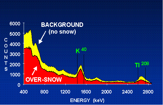
Figure 2 is a schematic representation of the various factors associated
with making and understanding airborne SWE measurements. It shows that
the airborne SWE value totals the moisture (regardless of phase) contained
in the snow water equivalent (SWE' ), ice lenses (IL), liquid water in
the snowpack (LW), ground ice (GI), standing water (SW), and superimposed
soil moisture (Ms). It also shows that the total soil moisture (Mt) in
the 8-inch soil zone is composed of the primary soil moisture (M) and the
superimposed soil moisture (Ms). The above characterization makes it possible
for an end-user to "recalculate" the reported airborne SWE value
by changing the primary soil moisture (M) to a more representative and
alternative primary soil moisture value (M' ).
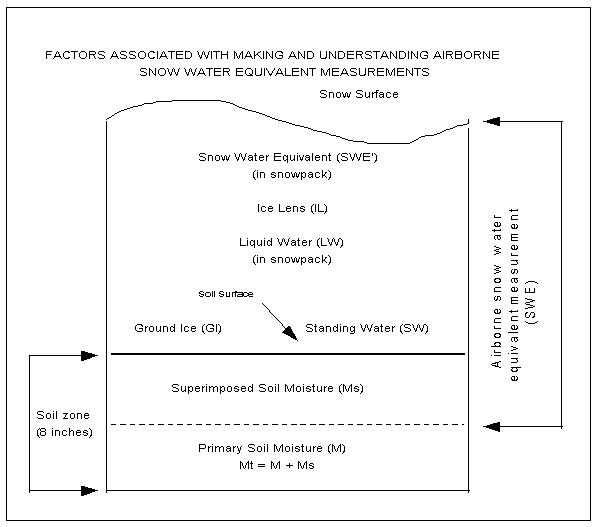
Figure 2. Factors associated withmaking and understanding
airborne snow water equivalent measurements.
To better understand what the airborne SWE measurement represents, it
may be useful to consider three different situations posed as a series
of questions:
- How much total liquid and solid moisture has accumulated since the
late fall? In this case, M should be set to a value which represents the
fall soil moisture condition. Ms will, quite likely, be significant and
represent moisture from later precipitation, midwinter snowmelt, and/or
moisture transported from the lower soil zones toward the surface due to
winter vapor pressure gradients near the soil surface. Consequently, the
resulting airborne SWE value will include a significant amount of moisture
in the soil (Ms) which exceeds the fall soil moisture value (M).
- How much above-ground moisture (SWE' + IL + LW + GI + SW) and soil
moisture (Ms) above field-holding capacity is present? In this case, the
primary soil moisture value (M) is set to field-holding capacity of the
local soil (typically 35 percent). This is an appropriate question in many
cases because the answer includes that portion of the soil moisture above
field-holding capacity which acts hydrologically very much like snow water
equivalent.
- What is the total above-ground moisture (i.e., the traditional SWE
value)? The answer is derived by setting the superimposed soil moisture
value (Ms) to zero and letting the primary soil moisture (M) equal the
total soil moisture (Mt). In this case, the value of M can easily be above
field-holding capacity and values of 50 to 70 percent soil moisture are
not uncommon. If M is an accurate estimate of the total mean areal soil
moisture in the upper 8 inches over a flight line, then (and only then)
the resulting airborne SWE will be an accurate estimate of the above-ground
moisture content. In this case, however, the airborne SWE value will NOT
account for the 15 to 30 percent soil moisture (1 to 2 inches of water
equivalent) in the soil above field-holding capacity which typically exists
and acts hydrologically like snow water equivalent.
In summary, airborne SWE measurements made using a value of 35 percent
or less soil moisture for (M) tend to generate a higher estimate than ground-based
SWE measurements, which tend to underestimate true SWE conditions
on the ground. Consequently, airborne snow measurements should be expected
to be a better measure of true ground snow cover conditions than
those provided by NWS cooperative observers and others using traditional
ground-based snow measurement techniques. It is essential to understand
this concept in order to fully understand the nature of airborne snow measurements.
Ground-based Snow Water Equivalent Measurements
Ground-based SWE measurements are typically made by an observer using
a snow tube and a scale, which give a direct reading of SWE. Snow tube
measurements tend to systematically underestimate true SWE because of the
sampling difficulties associated with ice lenses, ground ice, and depth
hoar. It is virtually impossible to accurately measure the water content
in ice layers on the ground that can be 2 to 4 inches thick. (An alternative
procedure used to make SWE measurements is to melt the snow sample to derive
the water equivalent, a technique encumbered with equal difficulty.) Additionally,
one point sample tends not to be representative of an area.
Airborne SWE values, however, include all the SWE, liquid water, ground
ice, and standing water above the ground. In addition, they may also include
some superimposed soil moisture (Ms) depending on the value of the primary
soil moisture (M) used in the SWE calculation. As a result of the tendency
for ground observations to underestimate true SWE and the possibility that
the airborne SWE value may include some soil moisture (depending on the
value of M used), ground-based SWE values tend to underestimate airborne
SWE measurements. Additionally, the reliability of one point estimate to
characterize the mean areal SWE of a 2 to 3 square mile area is suspect.
(The NOHRSC typically makes over 1,000 snow depth and density measurements
on the ground over a single flight line when we want a good ground measurement
of mean areal SWE to compare with airborne measurements.)
Airborne Snow Survey Program Products
All Airborne Snow Survey Program products are sent out over NWS communications
using the SHEF ID of MSPRRMASP and to the NOHRSC's web site in near real-time.
The SHEF IDs should be in the database of appropriate NWS offices in order
to receive the airborne data. The operational airborne data are transferred
to the NOHRSC from the aircraft each noon and evening. The data are checked
for accuracy, entered into SHEF, and sent to the NCRFC Gateway computer.
The product is then sent from the RFC Gateway computer to NWS field offices
approximately 2 to 3 hours after the survey aircraft land each day anywhere
in the country.
A typical airborne survey might take 3 or 4 days for one specific region.
As many as two or three airborne snow data products could be issued each
day during peak snow survey season. Airborne SWE products are provided
in graphical (figure 3) and text formats. Service Hydrologists should ensure
that the products appropriate for their area are archived in their database.
Text products provide airborne SWE data in SHEF and include the flight
line number, date of observation, percent snow cover (%SC), airborne SWE
in inches, airborne SWE calculated using a value of M equal to 35 percent
soil moisture (SWE 35%), percent soil moisture (M) used to calculate the
SWE (%SM(M)), the type of estimate for %SM(M), the date of a fall soil
moisture survey (if conducted), the fall percent soil moisture (%SM(F)),
and pilot remarks when appropriate.
Explanation of Airborne Gamma Data Format (SHEF)
The data from each survey is formatted into a specific NWS format called
a SHEF message. These messages are available from the Operational Products
section of the NOHRSC web page, as is a
guide to interpreting the airborne gamma survey SHEF messages.
Winter Airborne Snow Survey Schedule
There is no winter airborne snow survey schedule that is set and strictly
adhered to well in advance of the accumulation season. The locations and
dates for airborne snow surveys are established in real-time and are based
on national snow cover conditions. Some airborne snow surveys are scheduled
around the issuance dates for spring flood outlook products. The RFCs typically
issue four flood outlooks. The outlooks are scheduled for release to the
public by the WFOs on the first and third (or second and fourth) Fridays
of February and March. Airborne snow data are typically collected over
critical areas of the country before all but the first flood outlook. Each
RFC designates a focal point to interact with the NOHRSC on survey scheduling
and related matters.
Airborne survey schedules and basins for data collection are determined
approximately 10 days before each outlook release date. Consequently, it
is important for the designated Airborne Program focal point in each RFC
to contact the NOHRSC office to discuss the need for airborne surveys and
video coverage in their area before each flood outlook, if warranted by
existing snow cover conditions. Service Hydrologists should have similar
interactions with the NOHRSC to coordinate additional requirements if they
exist.
Summary
Reliable airborne SWE and soil moisture measurements are provided in
real-time to NWS field offices upon request from NWS hydrologists. The
airborne data are collected routinely over a network of more than 1900
flight lines in 25 states and 7 Canadian provinces from January through
mid-April. Airborne snow survey missions and basins for coverage are based
on input from NWS field hydrologists and snow cover conditions across the
country. The airborne SWE data are used to assess:
- The above-ground moisture held in the snowpack in the form of snow,
ice lenses, ground ice, and standing water;
- The above-ground moisture plus some measure of the soil moisture above
field-holding capacity (which tends to respond hydrologically in a fashion
similar to that of SWE); and/or
- The aggregate change in both the above-ground moisture and the total
soil moisture from some previously established measurement (e.g., a fall
airborne soil-moisture survey).
The airborne snow data collected in the late winter and early spring
are used by hydrologists from the NWS and other Federal and state agencies
when issuing spring flood outlooks, water supply outlooks, and river and
flood forecasts. Additionally, airborne soil moisture data are used operationally
each fall over large areas of the Upper Midwest to assess the antecedent
soil moisture conditions immediately before winter freeze-up.
The airborne data are transferred electronically from the snow survey
aircraft to the office in Minneapolis. They are checked for accuracy, entered
into SHEF, and sent to NWS field offices within 2 or 3 hours after the
aircraft lands each noon and evening for fuel.
The Service Hydrologist has the ability, with the information provided
on the web site, to "reprocess" any airborne SWE value reported
using a "new" and/or more representative primary soil moisture
value (M) in the original airborne SWE calculation.
Listed on the web site are several recent (and several not-so-recent)
publications which describe the airborne measurement technique, research
results, and other aspects of the Airborne Snow Survey Program of the NOHRSC.
Copies of the publications are available upon request.