 SNOW HYDROLOGY (GEOG 4321): IMPORTANCE OF SNOW
SNOW HYDROLOGY (GEOG 4321): IMPORTANCE OF SNOW
SNOW HYDROLOGY (GEOG 4321): IMPORTANCE OF SNOW
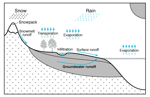
Mechanisms of water movement within the hydrological cycle (from Elements of Physical Hydrology by Hornberger et al.). Water movement from the atmosphere to the oceans and continents occurs as precipitation, including rain, snow, sleet, and other forms. On the continents, water may be stored temporarily, but eventually returns to the oceans through surface and groundwater runoff or to the atmosphere through evapotranspiration.
For this class, we concentrate on the contributions to the hydrologic cycle from snow and snowmelt. Additionally, we will investigate some of the unique properties of snow that result in phenomena such as avalanches.
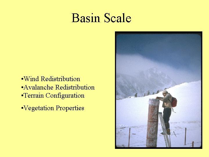
Our knowledge of snow is not consistent across scales. We know a lot about snow at the plot scale. However, this process-based knowledge does not scale-up to regional, continental, or global scales.
We can measure parameters such as snow-covered area at regional to global scales using remote sensing. However, it is not clear how to combine this information in a useful manner at the watershed to plot scale.
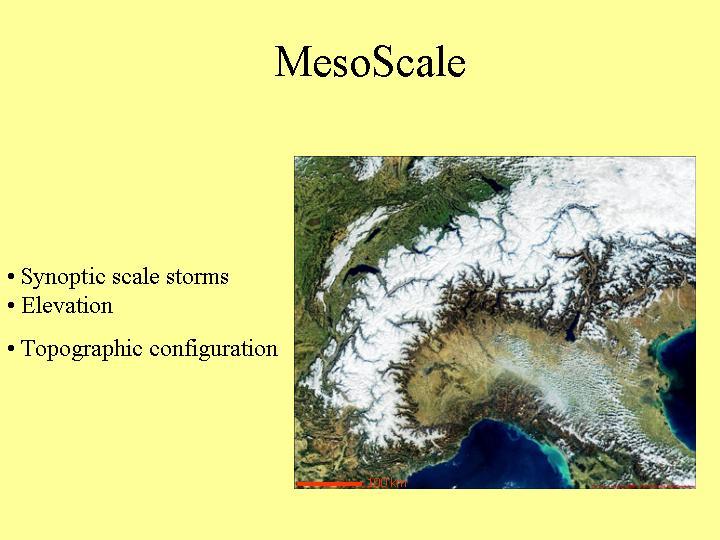
Following are some illustrations of different scales. Thanks to Paul Brooks.

Much remains to be learned concerning how snow properties change with changes in scale.
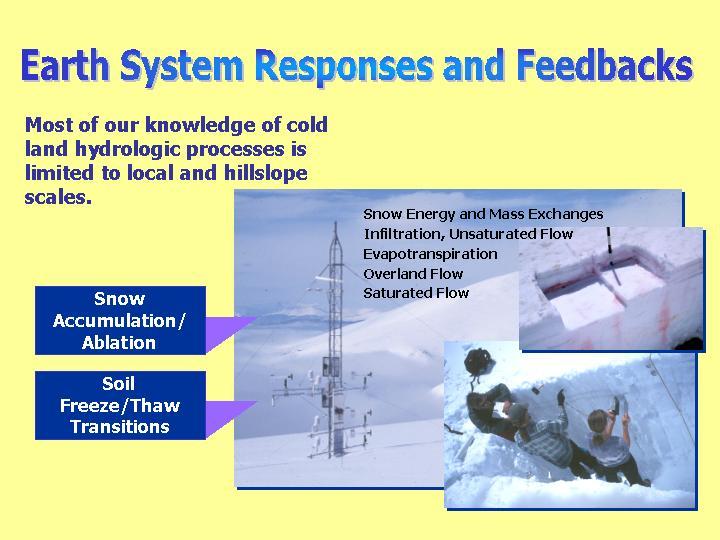
Much of our process-based knowledge has been conducted at the plot to hillslope scale.
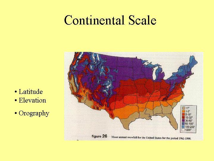
At the continental scale we can map bulk properties
such as snow-covered area and SWE.
However, these pretty maps don't work well at the
watershed to hillslope scale.
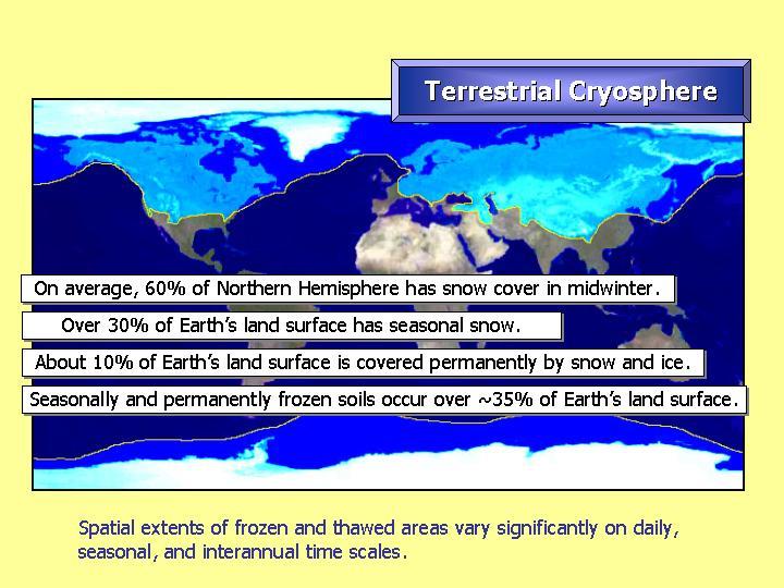 Overview of the cryosphere in the Northern Hemisphere.
The year 2003 promises to be the third-warmest global year on record, which should come as little surprise to Coloradans basking in balmy temperatures that feel nothing like Christmases of yore.
Scientists say the persistent warming trend - the 10 warmest years logged since 1880 have occurred since 1991 - is simply one more hint from Mother Nature that climate change is real and its impacts are measurable.
Already scientists - including local researchers - have documented rapidly melting ice, withering droughts, reduced crop yields, animals whose lives are finely tuned to temperature acting strangely, and heat and pollutants bleeding from cities to change cloud physics and rainfall intensity.
"I think the scientific world has tried to step up to do the studies that are necessary to nail down this issue of global warming,' said Warren Washington, a senior scientist at the National Center for Atmospheric Research in Boulder. "There are a lot of people intensely working on it.'
The editors of the journal Science this month lauded researchers who trotted out study after study, including documentation of the impacts of climate change, as producing one of the top 10 scientific achievements of 2003.
"The stream of studies suggesting global warming's impact on Earth and its inhabitants surged to a flood in 2003 with reports on melting ice, droughts, decreased plant productivity, and altered plant and animal behavior,' the journal's editors noted.
That flood of studies includes major papers by Colorado researchers.
For the past 50 years, humans have had the most dominant, detectable influence on climate change, according to a Science paper co-written by Boulder researcher Kevin Trenberth. "There is no doubt that the composition of the atmosphere is changing because of human activities, and today greenhouse gases are the largest human influence on global climate,' wrote Trenberth, head of the Climate Analysis Section at the National Center for Atmospheric Research.
And, as surely as today's sunset signals an official start to the weekend, temperatures pay homage to weekends. In American, Chinese, Japanese and Mexican cities, the difference between the warmest daytime temperatures and nighttime lows was sharpest over weekends.
Nature doesn't typically recognize weekends.
"Clearly, whatever is happening is human-induced,' said Susan Solomon, a senior scientist at National Oceanic and Atmospheric Administration's Aeronomy Laboratory in Boulder and co-author of a paper published in the Proceedings of the National Academy of Sciences. The research team speculated that aerosols, tiny pollutants that change cloud physics and affect temperature, might be responsible.
"I honestly have to say the actual mechanism remains unknown,' Solomon said.
The local research comes amid a flurry of projects around the globe studying long-range effects of human activity, be it heat bleeding from cities, soot coaxing snow to melt faster or shortened winters throwing wildlife out of sorts.
A tiny trip-up like a longer plant-growing season is enough of a disruption to set food sources such as caterpillars out and about earlier than predators expect. America's national parks are expected to see food-chain disruptions and conservation challenges as warmer temperatures shift vegetation and mammals.
"Some changes will require adaptation. Every creature and plant knows this. Others will be welcomed with restrained glee (i.e. warmer winters, longer growing seasons, a more fertile atmosphere),' countered John Christy, director of the University of Alabama's Earth System Science Center and a fan of conservative, not catastrophic, climate predictions.

January 1995
Watching it, understanding it, forecasting it, predicting how much water is in it--all this is a surprisingly large and intricate undertaking, one on which our society urgently dependsIn the language of the Irish, scholars say, there are a dozen words for "peat." In the language of the Arabs, we've been told, there are many words for "sand." I, for my part, grew up speaking a language in which there are perhaps a hundred terms for "snow," and I am not a native of Igloolik.
I learned some of those terms from a man named Mark Williams, a former ski-lodge operator who is a geographer at the University of Colorado and a specialist in the properties of snow. "If you're talking about snow crystals in the atmosphere," he told me recently, "well, then, there are scores of terms. There are needles and sheaths and columns. There are pyramids. Cups. Bullets. Plates. Scrolls. Branches. Dendritic crystals. Stellar crystals." And those are just some of the basic forms. Snow crystals also come in combinations. Stellar crystals with plates. Dendritic crystals with branches. Hollow bullets. Bullets with dendrites. Plates with scrolls. Plates with spatial dendrites. Rimed particles. Rimed needle crystals. Lump graupels.
Graupel-like snow with nonrimed extensions. Some of the names of snow crystals (branches, needles, bullets) are appropriately suggestive: in high wind, snow crystals can be as abrasive as sand.
After snow has fallen, the name for it picks up additional qualifiers as it begins to settle or drift, as heat and cold and wind and moisture and the snow's own weight begin to make their influence felt. Freshly fallen snow starts out as what Williams calls an "ice skeleton"--a loose scaffolding of crystals amid an enormous volume of air. To give his students an idea of the ratio of snow to air in a fresh snowfall, Williams has them compress a family-sized loaf of Wonder Bread to its smallest possible size. (It can be reduced to a two-inch cube.)
In fresh snow air can pass with little obstruction from the atmosphere through the snowpack to the ground: given life by differences in the temperature gradient, the snowpack breathes. But time changes that. The snow may metamorphose into what is called equitemperature, or ET, snow. This is snow at its most stable, the delicate crystals having matured into hardy granules in a snowpack of homogeneous temperature. It may turn into melt-freeze snow, more commonly known as corn snow or spring snow. Where the snowpack meets the warmer ground, there may form a weak and porous stratum of what is known as kinetic snow or sugar snow or depth hoar--by whatever name, the mother of avalanches. If the snow survives for more than a year, it may begin hardening into something called firn, which is a step on the way to becoming glacial ice.
I met Mark Williams and a good many of his colleagues at last year's meeting of an organization called the Western Snow Conference, a gathering that occurs every spring when the season's snows are more or less over and the period of snowmelt is well under way. Collectively, the people who attend the Snow Conference meeting--hydrologists,geographers, meteorologists, biologists, chemists, agronomists, utility-company officials, state and federal government officials, representatives of Indian tribes--are known in the gray language of official reports as the "snow-resource community." They are interested in every aspect of the hydrologic cycle of snow, from the formation of the first crystals to the accumulation of snowpack to the onset of snowmelt to the release of the last drops of runoff into the Pacific Ocean or the Gulf of Mexico. They are interested in avalanche theory, in the seeding of clouds with silver iodide to induce snowstorms, in how to add certain bacteria to water so that ski resorts can make snow at higher temperatures. For decades they have been interested above all in the following questions, which turn out to be complicated ones: How much snow has fallen in the western United States in a particular winter? How much water will it turn into? Where will that water go?
Snow dependency
Snow is a commodity we usually remember for either the pleasures it offers or the disruptions it causes. We call upon snow, too, for its utility as metaphor: symbol of purity, uniformity, isolation, protection, transience. We tend not to think about snow as the crucial variable upon which urban life and agricultural life in much of the world, particularly the United States--and especially the American West--happen to depend. Indeed, snow is largely missing, as the historian Bernard Mergen observes in a forthcoming study, from recent histories of water policy, in which one would expect it to play a highly visible role. And yet snow, hardened into glaciers, covers 10 percent of the planet's land area. Fresh snow falls each year on nearly one square mile of dry land out of every four; in the Northern Hemisphere the figure is one square mile out of two. Worldwide, at least a third of all the water used for irrigation comes from snow. In the western United States the figure is about 75 percent.
What makes snow important is not only its volume but also its relative dependability. Much of the West is in a state of drought or near-drought, with snowfall having been below normal in seven of the past eight years. In general, though, snow can be far more reliably counted upon to fall in substantial amounts in the mountains during wintertime than rain can be counted upon to fall in the spring and summertime. And snowmelt flows onto the scene at nearly the most useful time of year, having been stored at high altitudes until the weather warms and the demands of agriculture begin to make themselves felt. It is snow that powers the great rivers of the West--the Colorado, the Rio Grande, the Columbia, the Missouri--on their long journeys through sometimes parched or semi-arid terrain, ribbons of brown and silver that at times enverdure entire basins, at times support the merest Nilotic fringe of green. How much water does the West's winter snow turn into? The snowmelt that finds its way into the Columbia River alone in an average year comes to 26 trillion gallons, which is 81 million acre-feet--enough to cover all of Kansas in knee-deep water, or to raise Lake Michigan by almost six feet.
The Western Snow Conference typically holds its meetings someplace in sight of the mountains, where in springtime one can have a ready glimpse of snow. I was invited to attend the sixty-second annual conference, in Santa Fe, New Mexico, by a friend who is a hydrologist in California. I'm not sure why the prospect held such appeal, unless it is simply that snow is my favorite kind of weather. The first article I ever published, on a small printing press given to me on a snowy Christmas when I was six or seven, consisted of what was meant to be a report on snow depth in inches, and was distributed to neighbors. It read, in its entirety: "The snow 15." Snow seems to come into my life in the form of memorable coincidences. The Horatian ode "Diffugere nives . . . ," about the melting of snow in springtime, was the first piece of Latin verse I ever translated completely on my own (it appeared on a test), an achievement that occurred at roughly the same time as my first reading of James Joyce's short story "The Dead," whose most famous words, in the haunting conclusion, are "snow was general all over Ireland." Snow makes me feel as snug as a vole. There were ten major snowstorms in my region of New England last winter, and I contentedly wrote a check to the snowplow man each time.
The focus of the Western Snow Conference's Santa Fe meeting was "Climate Change Effects on Snowmelt Water Supply," a big and important subject, but that was by no means the whole agenda. "Northern Latitude Snow Pillow Installation Procedures." "Snow Accumulation and Ablation Under Fire-altered Lodgepole Pine Forest Canopies." "Snow Chemistry and Physics of the Mogollon Rim in Arizona." There was something here, I realized, for even the most jaded of tastes. At lectures and in associated readings I picked up such arcane pieces of information as that a two-foot square of snow ten inches deep contains about a million snowflakes, and that if the potential precipitation in the earth's atmosphere at any given moment fell all at once, it would cover the entire surface of the planet to a depth of one inch. I was pleased to observe that, as with any professional group that has reached a certain level of maturity, the membership of the Western Snow Conference includes people who display what might be called occupational anthroponymy--that is, whose names resonate with their line of work. I ran into a Phyllis Snow and a Neil Berg, and discovered that a type of diagram used to show inflows and outflows from reservoirs was devised by a man named Rippl.
During my days at the Snow Conference meeting I also grew to admire the pluck and ingenuity of those charged with keeping track of our snow. It has been nearly ninety years since James E. Church fashioned his first snow tubes and began taking wintertime measurements in the mountains of Nevada. Some things haven't changed very much since that time, and some have changed profoundly.
Falling crystals
''There is no material of engineering significance that displays the bewildering complexities of snow." I came across that matter-of-fact statement in the Handbook of Snow, an invaluable if glacially paced compendium edited by the eminent Canadian hydrologists D. M. Gray and D. H. Male. The formation of snow begins when water vapor or a supercooled droplet of water forms an ice crystal, almost always hexagonal in shape, around a nucleus consisting of one of the thousands of minute aerosol particles to be found in each cubic centimeter of the lower atmosphere--clay silicate, perhaps, or bits of volcanic ash, or material of extraterrestrial origin. From that moment on, the life of an ice crystal can be played out in various ways. The crystal may fall to the ground in its original form, as it does in the intensely cold regions of the Arctic and Antarctic. Or, more frequently, the ice crystal may grow into a snow crystal, gaining substance by means of sublimation--water vapor turning directly into ice, without passing through a liquid stage. Its shape, or "habit," will be determined mostly by temperature and the amount of water vapor in the air. As snow crystals descend, they may meet up with one another, forming aggregations. We know these as snowflakes. Or a snow crystal may in its descent encounter supercooled water droplets. Riming can then occur, as the droplets freeze immediately upon contact with a solid body. If the riming is substantial, the crystal may become graupel, or snow pellets.
All this activity has a powerful cleansing effect on the atmosphere--"washout" and "snowout," as two of the associated processes are called. A heavy snowstorm gathers particulate matter to itself and drags it to the ground, thereby preserving, until the snow melts, a sample of the atmospheric chemistry prevailing when that particular snowstorm began--a sample that speaks of climatic conditions generally and may speak more specifically of pollution. In the remote interior of Greenland, where the deposits of snowstorms do not disappear, such records go back a long way. A few years ago researchers at the Greenland Icecore Project drilled a hole through the Greenland icecap all the way to bedrock and extracted a core of ice that, if reassembled, would be close to two miles long. The ice at the bottom of the borehole is believed to have been formed from snow that fell some 200,000 years ago.
The symmetry of ice crystals was commented upon by the Chinese in the second century B.C. Europeans had recorded the same observation at least by the Middle Ages. The intellectual pedigree of snow scholarship in the West is distinguished. The Dominican scholastic Albertus Magnus wrote about snow crystals in the thirteenth century. At the beginning of the seventeenth century the same subject beguiled Johannes Kepler. "There must be some definite cause," he wrote in 1609, shortly after making the discovery that the planets travel not in circles but in ellipses, "why, whenever snow begins to fall, its initial formation invariably displays the shape of a six-cornered starlet. For if it happens by chance, why do they not fall just as well with five corners or with seven?" In his pamphlet Kepler drew parallels with honeycombs and the pattern of seeds inside pomegranates, but was unable to explain the flakes' hexagonal form. Somewhat later Rene Descartes discerned that branches sprout off each side of the stems of hexagonal snowflakes at an angle of 60 degrees, with an angle of 120 degrees thus separating the branches themselves. The process is complex, but the hexagonal shape of snowflakes essentially reflects the underlying atomic structure of water. One suspects that even the skeptic Descartes would have offered up a Te Deum had he known that the two hydrogen atoms in a molecule of water branch off the oxygen atom with about 120 degrees of separation.
For all the scientific awareness of the symmetrical character of snow crystals, the ubiquity of their popular image--the one we see in children's paper cutouts and on bags of ice and signs for motels that have air-conditioning--is a relatively recent phenomenon. What snowflakes actually looked like was not widely known until the middle of the nineteenth century, when the book Cloud Crystals, with sketches by "A Lady," was published in the United States. The lady had caught snowflakes on a black surface and then observed them with a magnifying glass. In 1885 Wilson Alwyn ("Snowflake") Bentley, of Jericho, Vermont, began taking photographs of snowflakes through a microscope. Thousands of Bentley's photomicrographs were eventually collected in his book Snow Crystals (1931). The fact that not one of the snowflakes photographed by Bentley was identical to another is probably the basis for the idea that no two snowflakes are ever exactly the same--an idea that is in fact unverifiable.
Into the tubes
Aesthetics did not drive snow science. Even as Wilson Bentley was peering through the camera bellows of his photomicrograph, Americans by the millions were continuing to settle the lands beyond the Mississippi. From 1870 to 1910 the population of California grew by 325 percent. During the same period the population of the eleven western states as a whole grew by 600 percent. The newcomers confronted firsthand a truth about the West presciently stated by the explorer and naturalist John Wesley Powell: "In the whole region, land as mere land is of no value. What is really valuable is the water privilege." Unlike water in the East, water in the West could not be taken for granted; rainfall was in many places nonexistent or seasonal. It was no secret that the snow that fell in wintertime turned into most of the water that appeared in spring--albeit unpredictably in terms of volume and timing. What if some element of predictability was possible? Imagine the consequences for the building and management of reservoirs, the control of flooding, the rational allocation of water among various kinds of users.
Riverine data in some form have been collected by all civilizations, so essential are rivers to commerce and agriculture. Records of the annual high-water level of the Nile, for example, are complete all the way back to A.D. 622, save for one large gap in the early modern period. The U.S. government in the mid-1800s began attempting to gather reliable meteorological information on its rapidly expanding and geographically diverse domains, and by the turn of the century runoff data in the form of hydrographs existed for many of the important western rivers. It occurred to a number of investigators that if, by means of a crude model, one could correlate, year after year, the size of the snowpack at the moment of its greatest extent--the moment of what is now called "ripeness"--with the streamflow, then one would have a powerful forecasting tool. Moreover, if one measured the snowpack not only at the moment of greatest extent, which usually occurs in April, but also in March, February, and January, and kept detailed annual records, one might even be able, eventually, to make a preliminary forecast as early as midwinter, based on past trends. Of course, even if this methodology worked to perfection, it would never reveal how much snow had actually fallen or how much water that snow actually contained. It could, however, reveal that this year's runoff had a certain probability of being, say, roughly 20 percent less than average, or 15 percent more.
That, at any rate, was the idea entertained at the turn of the century by, among others, James E. Church, an active outdoorsman who was a professor of Latin and Greek at the University of Nevada, in Reno. Church was animated in part by the situation of Lake Tahoe, which epitomized the competition for water in the West. In this case the competition involved farmers downstream, who needed the lake's water to irrigate their crops; a hydroelectric-power company, which operated several power plants on the Truckee River, whose source is Lake Tahoe; property owners on the lake, who wanted its level to remain constant; and the Paiute Indians, who by federal treaty were guaranteed a certain amount of Tahoe water to feed their Pyramid Lake. Being able to predict snowmelt would simplify the management of the lake.
Because evaluating water content was his aim, and because the water content of snow varies widely from storm to storm and even within the context of a single "weather event," Church contended that a simple depth measurement would probably not suffice. The old rule of thumb for snow-to-water conversion is that ten inches of "average" newly fallen snow make for about one inch of water, but some snow is much wetter and some is much drier. In Colorado, famous among skiers for its powder, twenty inches of snow or more may be needed to produce one inch of water. The samples that Church required in order to create a historical index had to reflect the water content, the "snow-water equivalent." Church therefore employed a stainless-steel cylinder, which he forced through the snow to extract samples from the surface of the snow to the ground. Once obtained, the samples would be weighed, weight being a reliable index of water content. Church's extraction instrument, which was more than six feet long, and onto which extensions could be screwed, came to be known as the Mount Rose sampler, after the mountain where he conducted his first surveys. Subsequent models have been waxed, polished, baked with silicon, and provided with teeth, and the stainless steel has given way to aluminum, but their design remains based on the original.
By 1911 Church and a U.S. Weather Bureau official named J. Cecil Alter were independently making systematic snow surveys, Church around Tahoe and Alter in the watershed around Great Salt Lake. They each developed the idea of the "snow course"--a series of sampling sites strung across a short distance, in order to reduce distortions caused by wind and drift. The very same sites, identified by tall markers, would be surveyed year after year, to ensure that the data were truly comparable. The surveyors' efforts were focused on the higher elevations, where there were no meteorological stations of any kind, and where, from the moment of first snowfall to the onset of spring thaw, the snowpack is less apt to melt: it is a more or less steadily accumulating resource. The altitude, though, brought problems of accessibility. Church and Alter and those who came after them had to trudge up to the snow courses on snowshoes and skis. There were blizzards to contend with. There were avalanches, and in the spring there were bears. I asked one veteran snow surveyor, Douglas Powell--a man who, as a graduate student, knew James Church, and who estimates that he has spent 1,600 days of his life in the high country on skis--if "grueling" was a word that accurately described the servicing of a snow course. He said no, the word he would use was "demanding," and he went on to tell about how once, in 1969, when he was conducting a survey in the Sierra Nevada, it snowed 150 inches in two days. Powell said, "All right, maybe grueling."
Laws unto themselves
As the idea of snow surveys caught on, promoted first by private interests and universities, then by state governments, and ultimately by the federal government, with James Church playing the proselytizing role of Saint Paul, snow courses began to spread throughout the western mountains. With them came a modest support structure. Photographs from the 1930s and 1940s show the log cabins built to sustain snow surveyors on weeklong treks through alpine country; many of the cabins were topped by a wooden tower twenty or thirty feet high--the "Santa Claus chimney." In late winter the snow would often be so high that only a door at the top of the chimney offered access to the snug safety of the cabin deep below. Besides physical comfort there was the comfort offered by a professional guild: the Western Snow Conference was established in 1933. (An Eastern Snow Conference was established several years later; its focus is somewhat less on snow as a resource, somewhat more on snow as a nuisance.)
Snow courses proliferated in the West--there were about a thousand of them by 1940--because the data they provided and the models they made possible proved useful. The models were not subtle. They were at first based solely on the amount of snow on the ground, with the data being used in an equation that was found, through trial and error, to produce a semi-satisfactory result. It was not long, however, before hydrologists realized that every basin, every watershed, worked in a different way. George D. Clyde, a Utah governor and one of the great names in American hydrology, put it this way: "Each watershed seems to be a law unto itself." Patterns of precipitation in the mountains of the Northwest turned out to be vastly different from those in the mountains of the Southwest. The assumption that the depth of the alpine snowpack greatly exceeded that of the snowpack at lower elevations proved to be correct in most places, but often not in Arizona or California. In Nevada the relationship was sometimes turned on its head: it all depended on whether storms tended to come in low or high, and on what stood in their way.
New variables had to be added. One of the first was soil moisture at the time of the first snow. If the weather had been unusually dry, much of the spring snowmelt would drain into the ground, and would not immediately show up in streamflow; unexpected shortages would occur. If it had been unusually wet, not only would most of the water in the snow cover run off but the increased contribution from water in the soil might build streamflows of a size no one had anticipated. Other factors, too, needed to be considered--elevation, wind speed, air temperature, radiation, slope of terrain, extent of snow cover, extent of tree cover, spring precipitation. As these were gradually incorporated into models, the models began to look more and more like something that aspired to show conceptually how the natural world really worked.
That process would take decades--indeed, is still going on, the state of the art currently being represented by the National Weather Service's powerful and intricate River Forecast System model. Even in their primitive state, though, snow-water forecasts were valuable. They could certainly warn of impending extremes--vast oversupply and vast undersupply. The record over the years buoyed confidence in reliability, and water commissioners took heed. Bankers reviewed the forecasts before deciding how much credit to extend to farmers. Farmers adjusted their acreage accordingly. In Utah the 1934 spring forecast by George D. Clyde indicated that streamflows in the state would run at 25 to 50 percent of normal; farmers scaled back their planting and ranchers moved their cattle to less arid grazing lands out of state, averting disaster in what would be remembered in other states as the year that brought on the Dust Bowl.
It was largely owing to the experience of 1934 that the federal government began to support and coordinate snow-survey work in the western states, and to conduct snow surveys of its own--a role the Soil Conservation Service took on in 1939 and retains to this day. The Depression era also witnessed a vast amount of spending on dams, reservoirs, irrigation canals--public works that harnessed the annual snowmelt but made forecasts of its volume all the more important. People in the eastern United States and even many in the West don't necessarily appreciate the intricate web of snowmelt-filled waterworks that makes the western United States possible. The Colorado River alone today feeds 1,470 reservoirs.
Will infrastructure-building and management of the interior ever again seem as heroic and progressive as they did during the 1930s? Life magazine, the television of its time, sent photographers to record snow surveyors on the job, following R. A. ("Arch") Work, one of the founding fathers of the SCS system, and a ranger named Jack Frost (!) as they trekked from course to course high in the Cascades. Looking back wistfully on this period, the author of one engineering textbook calls it "the First Golden Age of Hydrology."
Better data, better models
I sat down for an hour at the Snow Conference meeting with Eugene L. Peck, who is the president of a hydrological engineering firm called Hydex, and who for more than three decades was on the hydrological staff of the National Weather Service; his career there culminated with the directorship of the Hydrologic Research Laboratory. When I asked him how deep his roots went in American hydrology, he replied, "I had breakfast with J. E. Church at the meeting of the Western Snow Conference in 1950." The National Weather Service and the Soil Conservation Service, which collect snow data in different ways and cooperate on streamflow forecasts, had numerous disputes in decades past over issues of procedure and turf. Peck, who spent almost all of his career doing the basic work of hydrology in the western states--collecting data, improving models, mapping, forecasting--seems to remember them all. He may even have started a few.
I had asked Peck if he could give me a capsule history of snow forecasting in America, and he arrived with several pieces of yellow legal paper, a chronology sketched out from memory. The entries began with "1907-1910--J. Cecil Alter using stove pipe for cutter, Mill Creek nr SLC, UT" and went through "1950s--Competition between SCS & NWS, many problems but made for better forecasts," up through "1969-78--Development of airborne gamma radiation to measure water equivalent of snow cover," and kept on going.
Later Peck showed me a few items of historical interest: a half dozen delicate photographic negatives on glass, depicting snow-survey stations at Wagon Wheel Gap, in Colorado, during the 1920s; a sere and brittle copy of Volume 1, Number 1 (1920) of the Bulletin of the American Meteorological Society; a copy, preserved in a plastic sleeve, of a blue-bound pamphlet titled Snow Surveying: USDA Miscellaneous Publication No. 380 (1940), which was the first official manual for snow surveyors; and, typed on translucent onionskin paper, corrected by hand, the text of a lecture by J. Cecil Alter, "Read before the Utah Academy of Sciences, Salt Lake City, Utah, Saturday, April 3, 1926." I picked up the last of these items with a certain reverence. I felt as if I were touching one of the Dead Sea Scrolls of hydrology.
Peck, though, is no antiquarian. He is involved in, among other things, NASA's boreas project, which is an ambitious attempt to create a meteorological and hydrological portrait of large parts of Canada ---a portion of the continent whose freshwater resources in the form of snowmelt go largely uncaptured. In our conversations about snow and the water it contains Peck kept coming back to one basic point: that snowmelt forecasting still depends on having some sort of data and some sort of model to plug the data into. The story of forecasting, then, is the story of a search for better data and better models.
There has from the beginning been a school, for example, that held that data gathered from precipitation gauges--open buckets, basically--could be used to predict streamflow as reliably as data from snow surveys done with snow tubes. Snow-tube surveys did have obvious disadvantages. As noted, they were arduous. They were labor-intensive and therefore costly. And frequently snow courses were sited in areas that, for one reason or another, proved unrepresentative of the actual snowpack. Precipitation gauges were easier to get to--they tended to be at lower elevations--and could even be automated. They could provide information about rain as well as snow. But precipitation gauges had drawbacks too. Even when they were equipped with shields, for example, high winds would impel much snow laterally across the orifice, in a process called eddying. The result was "undercatch": the gauges would underreport the volume of snow.
Precipitation gauges, too, can be sited in unrepresentative areas, a problem occasionally abetted by human agency. Peck told the story of the weather station in Shoshone, Colorado, whose precipitation-gauge data had been so erratic and variable that Peck, who at the time was the head of the National Weather Service's water-supply forecast unit, in Salt Lake City, decided to visit the place and talk to the man who had run it for years and years. "I found the can," Peck said. "It was hooked onto a metal stairway where the snow could slide into it off the roof. But precip couldn't get in there, it was up so close to the building. So I said to the old guy, 'Well, how long's it been there?' And he said, 'Actually, quite a while. You know, originally it was out by the highway, in the thirties.' And I said, 'What happened?' And he said, 'Everything went fine--it really was a good place--except when the snowblowers on the highway began blowing snow over it and it started filling up. So we decided to move it. We moved it behind the station, but the tree grew up and was covering it. So we moved it up by the school ground. But that didn't work too well, because we started getting precipitation when there was no precipitation. Kids were using it for a urinal.'"
Beginning in the 1960s, Peck went on, forecasters began experimenting with a device called a snow pillow. A snow pillow looks like a very large ravioli made of neoprene rubber or pliable metal. It is a square, perhaps six to ten feet on a side, and is filled with antifreeze. As snow falls and the snowpack gets heavier, the pillow is compressed; the degree of compression, reflecting the weight of the water above, is communicated by radio to a monitoring station. One great advantage of snow pillows is that they can be placed securely in remote locations, where they will transmit data throughout the winter. But they are prey to a variety of ailments. One is called "bridging": periods of thaw or rain followed by a freeze can result in the creation of a reinforced support layer or even a static frozen dome over the pillow, which effectively tricks it into thinking that no further accumulation has occurred when it has.
My conversation with Peck was suspended when a lecture began on the subject of the algae that live in snow and feed on the nutrients in it. The organic material the algae excrete may support colonies of bacteria, and the algae themselves serve as food for several varieties of snowworms. Sometimes algae are so prevalent that the snow turns red or yellow or blue; the colored snow may exude the smell of fresh watermelon. The lecture revealed one more novel element in the unfolding dynamic of snow--the fact that snow is an ecosystem. By the time the lecture began, Peck had gotten as far on his sheets of legal paper as "1979--Thomas Carroll to direct operational program in Minneapolis, MN." He was, it seemed clear, just getting going.
The strategic snow command
There is a certain cast to the people who attend meetings of the Western Snow Conference. It is not, of course, exhibited universally, though I suspect that it would clearly emerge if one were somehow to add everyone together and take the mean. They are mostly men and mostly at the lower end of middle age. They seem to be independent-minded, friendly, physically fit. They are given to calling precipitation "precip," and partial to neatly trimmed facial hair and the kind of casual clothing one associates with people who do enlightened and brainy things outdoors. Formality never exceeds a bolo tie, the color of whose string indicates regional affiliation. The design of the clasp tends to reflect the year of one's first attendance at the Snow Conference; there were clasps around me going back to the 1940s.
One senses that there may be something of a division inside the Western Snow Conference between a younger generation that holds a firm faith in what new technology can accomplish and an older generation that idealizes tramping about in snowshoes with a Mount Rose sampler. Even so, the nature of the work brings out a bit of the mountain man in almost everyone. I cautioned one hydrologist, who was about to make the harrowing drive up the mesa to nearby Los Alamos, "Hold on to your hat. It's pretty steep." He looked at me as if to say, "I could do steep in my sleep."
No one intends to give up the traditional manual outdoor snow surveys. Not only are they part of the romance that drew many people into the field to begin with, but, more important, they contribute an indispensable something for which, in this age of remote sensing, a specialized term has been developed: "ground truth." With respect to the specific variable of water content, snow surveys set a standard that other methods can only measure themselves against. Many of James Church's original snow-survey courses in the Sierra Nevada are loyally maintained to this day.
Still, the forecasting business has made some important advances during the past few decades (a period known to some as the Second Golden Age of Hydrology). In addition to the 1,600 or so traditional mountain snow courses that the Soil Conservation Service and other agencies continue to run, the SCS operates 550 SNOTEL (for "snow telemetry") sites in mountainous areas throughout the West, each with an array of snow pillows, precipitation gauges, and sensors to record temperature and sometimes other variables, such as wind speed and soil moisture. Information is brought back to headquarters by means of "meteor-burst transmission": a request signal from one of the two SNOTEL master stations is bounced to remote sites not off a satellite but off the ionized trails of some of the billions of tiny meteors that enter the earth's atmosphere every day; the remote stations bounce back their most recent data in the same way. Forecasting agencies still send out on paper monthly state-by-state bulletins, but increasingly all the relevant data is available electronically, often in real time or near-real time.
Actually, the term "data" is beginning to sound a little limited. The National Weather Service in its publications refers to what it inclusively calls "airborne and satellite snow-cover products." I spoke with Thomas Carroll, who was the chairman of the executive committee of the Santa Fe meeting, and who since 1979 has been the director of the weather service's National Operational Hydrologic Remote Sensing Center, which is based in Minneapolis. For much of North America the center functions as a kind of Strategic Snow Command. The NWS, Carroll said, runs snow courses after a fashion--more than 1,850 of them, in twenty-six states and seven Canadian provinces. Each one is about ten miles long and is monitored by aircraft. The basic idea behind these very long snow courses is relatively simple. The earth's surface emits natural gamma radiation from trace elements of potassium, uranium, and thorium in the soil. That radiation is attenuated by the amount of water in the snow. An estimate of water content can be obtained along any of the established flight lines by comparing a background reading previously made over bare ground with a fresh reading made over the same piece of ground under snow.
There are limitations. "All methodologies have deficiencies," Carroll said, and he frankly ticked off the ones that characterize his flight-line network. "One, we have to fly close to the ground --five hundred feet--so we can only fly in good weather. Two, flying close to the ground means that terrain is also a problem. We can do some mountain areas, but we can't do others. Three, when the snowpack gets above eight, ten, twelve feet, the gamma-radiation technique turns to mush. The biggest limitation of all is the cost. It takes a lot of money to fly airplanes."
The snow-water-equivalent estimates from overflights, like those derived from any snow course, represent only samples. But already it is possible to merge, using computer models, sample surveys of every kind with continent-wide snow-cover imaging obtained by microwaves from satellites. The images will be getting better. Last October the space shuttle Endeavour made its second series of experimental investigations (the first was in April) with a new radar system capable of looking at the snowpack. A powerful multipurpose remote-sensing platform called the Earth Observing System, consisting of several integrated satellites, is scheduled to go into operation in 1998, with a $7 billion array of earth-monitoring equipment that will make the present Landsat satellite seem like a stereoscope in a Victorian parlor.
As we discussed satellites, Tom Carroll repeated, "All methodologies have deficiencies." The advantage of microwaves, Carroll said, is that they can see through clouds. The disadvantage is that they can show with confidence only the areal extent of the snowpack. They are much less able, given the present state of technology, to extract accurate information about water content. "That's a big problem," Carroll said. "Big problem." Even so, he went on, just being able to see the areal extent of the snow cover can make an important difference. Consider what happened in 1983 in the Colorado River basin. Forecasters knew from sampling that the water content of the snowpack was running about 200 percent of normal--"There was a lot of snow all over the shop"--and were expecting much more than the usual runoff. Typically what happens in the West is that the lower elevations warm up before the higher elevations, and the runoff is therefore gradual, drawn out over time: what is known as a "soft landing." In 1983 there was very little early-spring runoff. Scattered local reports indicated that the lower snowpack was still in place, but no one had any idea of the vast size of the phenomenon. The weather stayed cold all through the spring, and then a weather system moved in and warmed the entire snowpack all at once. Big problem. "If we'd had a program then to monitor areal extent of snow cover," Carroll said, "we'd have noticed the anomalies in the lower elevations. We could have been more responsive."
Being "responsive" in this case would have meant releasing water from reservoirs downstream to accommodate the coming torrent. As it was, in 1983 the Colorado River spilled over the top of the Hoover Dam, creating a western version of Niagara Falls. Flooding in the Colorado basin did not end until autumn. Looking back at newspaper accounts, I noted with satisfaction that the federal official charged with overseeing the Colorado River dams was named Plummer.
The future of snow
For all the improvements in detection, though, there remains something fundamentally unsatisfying about the forecasting endeavor. One hydrologist I met at the Snow Conference meeting resorted to a medical analogy. We have gone, he said, from the equivalent of Laennec's wooden tube to the stethoscope to the electrocardiogram in the space of a generation, but, as with the human body, we still don't know many fundamental things about snow. Nor do we understand its relation to weather and to climate--the dynamics of climate being one of the perennials on the "must figure out" list of science. And although, as in medicine, we can predict the likely course and consequence of certain conditions once they arrive, we find it a lot harder to predict the onset of many of those conditions very far in advance.
That is one of the tasks for the future. The Snow Conference meeting offered glimpses of some avenues of research. One paper speculated about a possible relationship between the size of the Himalayan snowpack in a given year and the size and timing of the subsequent monsoon. Another paper sought to document a link between the periodic El Nino warming trend and diminished snowfall in the Pacific Northwest, a link that would have practical significance for forecasters if the onset of El Nino could consistently be determined in advance. (I overheard someone behind me snort and say, "Yeah, but try telling water-conservation officials that you think there's going to be a shortage because of the barometric pressure in Tahiti.") Several papers looked ahead to what would probably happen to precipitation and snowmelt in certain locales in the event of global warming. One of them, which assumed a 3 degrees Celsius increase in average temperature, concluded that the volume of precipitation in the Sierra Nevada would not be much affected but the timing of the snowmelt would: nearly a third of the precipitation that would ordinarily appear as runoff in springtime, when farmers can use it right away, would appear as runoff in wintertime instead, meaning significant losses for watersheds that don't have adequate means of storage.
Even as global climate and large-scale circulation patterns affect snowfall, snowfall has a considerable impact in return, given that gains and losses of energy in the atmosphere are what swirl air masses around the planet. There is no natural surface on earth with a higher albedo--reflective power--than fresh snow. A field of planted farmland may reflect back as little as three percent of shortwave solar radiation. The Mojave Desert may reflect as much as 30 percent, sea ice as much as 40 percent. Fresh snow may reflect fully 95 percent. Rather than being retained as heat, the sun's energy is sent back where it came from. The melting of a winter's worth of snow takes so much energy that even though the sun in the Northern Hemisphere is at its most intense in June, the atmosphere remains cooler than it "ought" to be until August.
All the earth sciences began as applied sciences, spurred by basic considerations of economics and survival. In helping to organize the Western Snow Conference, James E. Church expressed the hope that the study of snow might be broadened beyond the pragmatic and the empirical. To some extent this is happening. Snow studies are, of course, still pragmatic, sometimes in ways that those in the so-called progressive conservation movement of the late nineteenth and early twentieth centuries would never have anticipated. In the current period of drought, for instance, utility companies and water authorities are conducting cloud-seeding experiments in many areas of the West as part of an attempt to see if more snow can be put on the peaks. (Such efforts in the past resulted in some well-publicized legal tangles when snow suddenly fell in an unexpected place.) Snowmelt forecasting will also play a big role as states throughout the West, under various mandates, begin to restore depleted rivers and lakes. To the list of competing uses for the snowpack's water, in other words, we must now add another.
As I prepared to leave Santa Fe, the space shuttle Endeavour was high overhead, in the midst of a successful ten-day test of its new radar. I drove north out of town to the banks of the Rio Grande, which flows through a broad plain between the Jemez and the Sangre de Cristo mountains. The snow in the lower elevations had begun to melt, and the river, though it was still shallow and slow-moving, had begun to rise. According to the newspaper that morning, the Sangre de Cristo Water Company's reservoirs in the Santa Fe Canyon, which trap the spring snowmelt and were now nearly full, would be releasing water into the Rio Grande in a matter of weeks. Looking up, I could see the alpine snowpack--still intact, and, on average, about ten feet deep, according to information I had received from the Soil Conservation Service. Or, as I might have put it at another time, "The snow 120." The cottonwoods along the Rio Grande displayed the haze of fuzzy lime-green they briefly exhibit every spring, reminding me that this was exactly the time of year that Horace had been writing about: "The snows have dispersed, now grass returns to the fields and leaves to the trees."
All those former needles and sheaths, those cups and bullets, those dendrites and stellar crystals--they were dispersed, or dispersing, to be sure. But, fortunately for all of us, they would be back.
This article was originally coded for the Web in 1995 by Michael J. Albrecht and John Ashley at the University of North Carolina at Chapel Hill.
Copyright © 1995 by The Atlantic Monthly Company. All rights
reserved.
The Atlantic Monthly; January 1995; In Praise of Snow; Volume 275, No. 1;
page(s) 45-58.