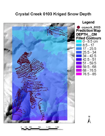
Snow depth measurements in the Crystal Creek drainage,
January 2003, Northern Elk Winter Range, YNP
Craig has been trying to document each field session with a few photos here and there. Feel free to use any of the posted Yellowstone images. He also have many other pictures that he would be willing to share.
The directories are organized in yymm format. Please feel free to contact Craig if you would like additional information about a specific image. Thanks.
GIS coverages and digital elevation models are an important component of this research. Thanks to the National Park Service for providing about 40 coverages along with 10-m and 30-m DEM's: GIS coverages, doc file,
Distributed estimates of snowpack properties and the climatic processes that
control them are integral in gaining a more comprehensive understanding of complex
ecosystems.
The Northern Elk Winter Range (NEWR), located in the Greater
Yellowstone Ecosystem (GYE), is an exemplar of such a complex ecosystem.
Ungulates, specifically elk, are a key biotic component of the NEWR.
Migration, predation, feeding patterns and herd distribution of elk are all
greatly influenced by winter snowpack properties including depth,
density, temperature, grain size and snow water equivalence(SWE).
This research is designed to develop an approach to spatially and temporally
distribute these snowpack properties over the NEWR in order to better estimate energy
expenditures of elk with respect to variable snowpack conditions.
A 1-dimensional energy and mass balance model,
SNTHERM.89, is in the process of being applied to each 30-m pixel in the
Crystal Creek drainage, a 1,000 ha catchment located in the heart of the NEWR.
The model is initialized with snowpack properties estimated from measurements taken in
January 2003 (see image above for results).
About 1,200 measurements of snow depth and GPS location were collected in January 2003,
along with stratigraphy measurements from 20 snowpits.