 SNOW HYDROLOGY (GEOG 4321): MEASURING SNOWFALL AMOUNT
SNOW HYDROLOGY (GEOG 4321): MEASURING SNOWFALL AMOUNT
SNOW HYDROLOGY (GEOG 4321): MEASURING SNOWFALL AMOUNT Readings:
Web Sites for Snow Measurement Programs
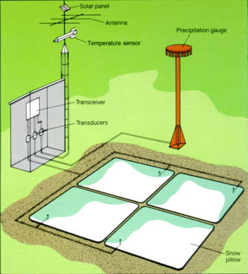
The meteor burst technique allows communications between two locations as much as 1,200 miles apart. Two master stations -- at Boise, Idaho, and Ogden, Utah -- cover the 10 Western States, an area of about 1 million square miles. By cable, the master stations feed the data to SNOTEL's Centralized Forecasting System in Portland, Oregon. The Alaska Meteor Burst Communication System (AMBCS) for snow surveys is similar. All remote SNOTEL sites are interrogated daily on a regular schedule. Additional interrogations can be conducted on demand, and any special reporting requirements can be programmed into the site's microprocessors. In the Alaskan system, hourly interrogations are conducted, and the data are made immediately available to cooperating agencies.
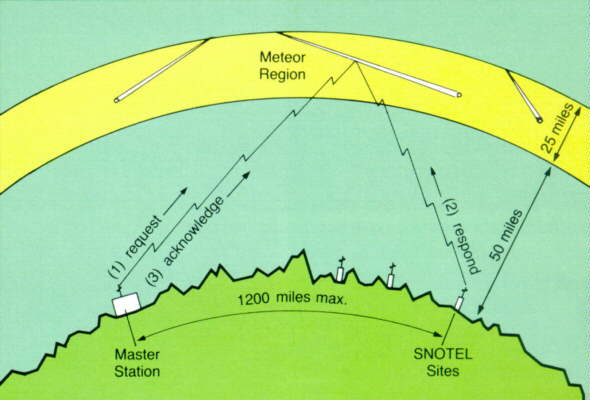
Billions of sand-sized meteorites enter the atmosphere daily. As each particle heats and burns in the region 50 to 75 miles above the Earth's surface, its disintegration creates a trail of ionized gases. The trails diffuse rapidly, usually disappearing within a second, but their short lifespan is adequate for SNOTEL communications to be completed (fig. 14).
The process has three major steps: (1) master stations request data from remote sites; (2) sites respond by transmitting their current data; (3) and finally a master station acknowledges receipt and signals the site transmitter to stop. This complex exchange, taking place in a fraction of a second, is possible thanks to microprocessors.
The ability to make reliable airborne gamma radiation SWE measurements is based on the fact that natural terrestrial gamma radiation is emitted from the potassium, uranium, and thorium radioisotopes in the upper 8 inches of soil.
From the Snow Booklet, pages 41-44.